
Burnaby Lake: 19 km of trails and 214 bird species
Short answer: Burnaby Lake Regional Park wraps a 3.11-square-kilometre glacial lake in Burnaby, with 19 km of trails, boardwalks at Piper Spit, a nature house, and 214 bird species recorded through the year. Colonel Moody's 1859 survey party found and named the lake.
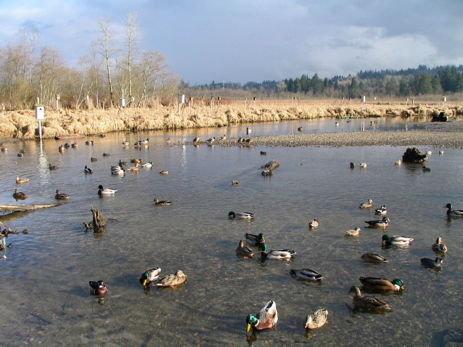
* Cover photo: Flying Penguin, Wikimedia Commons, CC BY-SA 3.0
Burnaby Lake is the quiet counterweight to Burnaby's towers: a 3.11-square-kilometre glacial lake ringed by marshes, boardwalks, and 19 kilometres of trails, sitting between Highway 1 and the CN rail line minutes from Metrotown. For Tri-Cities residents it is the closest major birdwatching site in the region, and its origin story involves a rain-soaked expedition ordered by the founder of New Westminster.
Moody's rainy-day discovery
The lake formed about 12,000 years ago at the end of the Pleistocene ice age, but its recorded history begins in March 1859, when Colonel Richard Clement Moody was surveying New Westminster as the capital of the new Colony of British Columbia. Hearing from Indigenous residents that a freshwater lake existed north of the townsite, Moody sent his private secretary Robert Burnaby and a small party to find it, writing to Governor James Douglas that he had let them go "in the most deplorable weather" with four days' provisions and "not even tents."
The party returned safely, and the official 1860 hydrographic chart recorded two discoveries: Burnaby Lake, named for the secretary, and the Brunette River, which drains it east to the Fraser. Sawmills lined the lake in the late nineteenth century, and the BC Electric interurban line ran along its south shore. Metro Vancouver's parks department has managed the park since 1977.
A wildlife city
More than 400 species of plants, birds, fish, mammals, reptiles, and amphibians live in the park, and the bird list is the headline: at least 70 species make the lake home and about 214 species visit through the year. Great blue herons, bald eagles, osprey, and green herons are regulars. The marshes of bladderworts, cattails, bulrushes, and sedges do double duty as a giant settling pond, filtering pollutants from Still Creek before water flows out through the Brunette River, where the Cariboo Dam controls outflow to prevent downstream flooding.
All that sediment comes at a cost. The lake gradually filled in until, by 2005, it was too shallow for competitive paddling and parts risked becoming mudflats. The Burnaby Lake Rejuvenation Project dredged 360,000 cubic metres of sediment in August 2006, restoring open water.
Trails, towers, and paddles
Nineteen kilometres of walking and hiking trails circle the entire lake, passing the Burnaby Lake Nature House, a butterfly garden, and the park's signature viewpoint: the Piper Spit pier, a boardwalk out into the marsh where ducks, geese, and blackbirds feed at arm's length. The Burnaby Equestrian Centre anchors 6 km of horseback riding trails along the southern and eastern shores.
On the water, the Burnaby Canoe and Kayak Club and the Burnaby Lake Rowing Club operate from the Burnaby Lake Pavilion at the lake's west end, keeping a paddling culture alive on the dredged course. The park is also home to the Wildlife Rescue Association, which treats thousands of injured wild animals a year. Note that the lake's sediment, peat, and lilies make it unsuitable for swimming.
Visiting from the Tri-Cities
Burnaby Lake is about 15 minutes from Coquitlam via Highway 1, with entrances and parking at Piper Avenue, Avalon Avenue, and the sports complex off Sprott Street. The park opens at 8 a.m., closing at 9 p.m. from the start of daylight saving time to Labour Day and at dusk the rest of the year. For a first visit, park at Piper Spit and walk the boardwalk at feeding time; few wildlife experiences this good sit this close to the Tri-Cities.
The Brunette connection
The lake sits at the centre of a small watershed that Tri-Cities residents know better than they realize. Still Creek, Eagle Creek, and Deer Lake all drain into Burnaby Lake, and the lake empties east through the Brunette River to the Fraser, meaning the water passing the Piper Spit boardwalk is headed for the same Fraser shoreline that runs past Port Coquitlam and Maillardville. The Cariboo Dam on the Brunette controls the outflow rate, protecting downstream neighbourhoods during heavy rain.
The rail line on the lake's north shore and Highway 1 on the south frame the park with the region's busiest corridors, which makes the quiet inside feel almost illicit. Step five minutes off Piper Avenue and the traffic fades behind cottonwoods and cattails.
A working conservation landscape
Burnaby Lake is not preserved so much as managed, and that is its lesson. The 2006 dredging kept the paddling course and open water viable; the Wildlife Rescue Association treats thousands of injured animals each year from its base in the park; and the nature house and butterfly garden turn casual visits into entry points for stewardship. For Tri-Cities families, it is the easiest place in the region to turn a walk into a wildlife education.
* Cover photo: Flying Penguin, Wikimedia Commons, CC BY-SA 3.0
FAQ
Can you swim in Burnaby Lake?
No. Sediment, peat moss, decomposing plants, and water lilies make the lake unsuitable for swimming. Come for the trails, birdwatching, and paddling instead.
What is Piper Spit?
Piper Spit is the park's famous boardwalk pier, extending into the marsh at the lake's east end. Waterfowl gather at the viewing area, making it one of the best close-up birdwatching spots in Metro Vancouver.
Who was Robert Burnaby?
Robert Burnaby was Colonel Richard Moody's private secretary, who volunteered to explore north of the New Westminster townsite in 1859. Moody named the lake for him, and the city later took his name too.
Sources
Follow Tri-Cities Daily
Daily local news, events and guides on Instagram: @tricitiesdaily
Related stories
Derby Reach: camping and trails on Langley's Fraser shore
Derby Reach Regional Park pairs Fraser River trails and heritage orchards with the Edgewater Bar campground and the Fort-to-Fort Trail into Fort Langley.
Mill Lake: the Abbotsford mill pond that became the city's front yard
Mill Lake anchors central Abbotsford with a loop trail and boardwalks, but it began as a Sto:lo fishery and boomed as one of BC's biggest sawmill sites.
Alouette Lake guide: Maple Ridge's mountain reservoir
Alouette Lake stretches 16 km beneath the Golden Ears, was renamed in 1914, and hides a dam-and-tunnel power story. Beaches, paddling, and history.